 Growth Management Law Change
Planners Mapping Tool
Town specific Planners Maps for Washington County towns provide a more sophisticated web-based tool for Planning Boards and Code Enforcement Officers.
 Please take our 5-minute User Feedback Survey — help us improve the online mapping tools and training resources — Thanks!
Like the Public Parcel Viewer these web maps provide location and data on:
- taxmap parcels (with a link to Washington County Registry of Deeds)
- Public Facilities
To assist with planning and regulatory review the Planners Maps also depict up to date information on:
- Proposed Land Use from municipal Comprehensive Plan (if available)
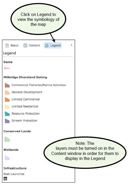
- Shoreland Zoning
- Conservation Land
- Wetlands
- Development infrastructure
- Public Services
- Shellfish habitat
- DEP Tank Sites
- Brownfields sites in varying stages of assessment and redevelopment
- Agricultural soils, farms (under development)
- Clams, Economy and Land Use (under development)
- Aquifers and public water supplies (under development)
- Beginning with Habitat data (under development)
Planners Maps for Washington County towns are provided below.
As with the Public Parcel Viewer data can be added and the University of Maine at Machias GIS Service Center is making a long term commitment to keeping it up to date and as useful to communities as possible. If you find errors, have updates, want more information or would like to arrange some training for your local officials please contact Judy East or Tora Johnson.
The Public Parcel Viewer and Planner Maps for Washington County towns are the products of several years of work by the students, graduates and employees (and employed graduates!) of the UMM GIS Service Center. Under the supervision of Director Tora Johnson they contributed countless hours of time in the creation of these maps:
 digitizing (sometimes from pencil on a paper base map from the 1870s)
- interpreting deeds
- contacting municipal officials from every town in Washington County
- finding, connecting, integrating and presenting data
- pushing the limits of the software
- demanding new tools of the software engineers
- beta testing and refining the software
- modeling legislation into shoreland zoning districts
- preparing instruction guides
Use the on-line maps HELP function or
download the Planners Map PDF Instruction Guide here.
download Instructional Videos here.
Remember: GIVE the maps TIME to load - you will see the base map for awhile as the layers load especially if you have a slow internet connection.
Planners Maps
Please take our 5-minute User Feedback Survey — help us improve the online mapping tools and training resources — Thanks!
- Addison Planners Map
- Alexander Planners Map
- Baileyville Planners Map
- Beals Planners Map
- Beddington Planners Map
- Calais Planners Map
- Charlotte Planners Map
- Cherryfield Planners Map
- Columbia Planners Map
- Columbia Falls Planners Map
- Cooper Planners Map
- Crawford Planners Map
- Cutler Planners Map
- Danforth Planners Map
- Deblois Planners Map
- Dennysville Planners Map
- East Machias Planners Map
- Eastport Planners Map
- Harrington Planners Map
- Indian Township Planners Map
- Jonesboro Planners Map
- Jonesport Planners Map
- Lubec Planners Map to Top
- Machias Planners Map
- Machiasport Planners Map
- Marshfield Planners Map
- Meddybemps Planners Map
- Milbridge Planners Map
- Northfield Planners Map
- Pembroke Planners Map
- Perry Planners Map
- Pleasant Point Planners Map
- Princeton Planners Map
- Robbinston Planners Map
- Roque Bluffs Planners Map
- Steuben Planners Map
- Talmadge Planners Map
- Topsfield Planners Map
- Vanceboro Planners Map
- Waite Planners Map
- Wesley Planners Map
- Whiting Planners Map
- Whitneyville Planners Map to Top
Share this content: